Survey and construction equipment is built rugged by design. It has to be tough to withstand the dust, water, and other rigours of use in outdoor construction environments. With that in mind, servicing equipment regularly still plays a large part in ensuring the longevity of it’s working life. To keep your equipment operating accurately and… Continue reading Are You Putting Off Equipment Repairs?
Tag: Utility Detection
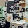
Locate Underground Objects | Leica GPR
The Leica GPR solution provides roading, earthworks, concrete contractors and council developers/asset managers the ability to quickly analyse underground objects across large areas. Risks can then be identified and minimised before earthworks begin, greatly improving safety onsite. The advantage of using Leica GPR is the ability to quickly see a full picture of what’s going… Continue reading Locate Underground Objects | Leica GPR
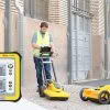
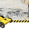
Leica DS2000 GPR – Discover what’s going on underground
With the Leica DS2000 GPR you’re now able to quickly and safely locate a full range of utilities for a complete picture of what’s going on underground. Ground Penetrating Radar works by using radar technology to create an underground profile of buried items including cables, metallic and non-metallic pipes [concrete, plastic and clay pipes] and… Continue reading Leica DS2000 GPR – Discover what’s going on underground
Safer, Faster Utility Detection with Leica GPR
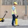
Within the construction industry, there is growing demand for intelligent, easy to use, reliable products that deliver dependable outcomes faster than before. The main issue when detecting underground utilities is being able to obtain reliable, accurate results in order to ensure site safety once earthworks begin. Inaccurate or out of date underground utility data can… Continue reading Safer, Faster Utility Detection with Leica GPR
Leica Pegasus | Mobile Reality Capture

Leica Geosystems offers a complete portfolio of mobile mapping solutions capturing point cloud & imaging data. Now there are two highly accurate mobile scanning solutions to choose from: Leica Pegasus:Backpack is the award-winning wearable capture solution. Leica Pegasus:Two is a vehicle-independent mobile mapping platform. Watch the video to see them in action! The Leica Pegasus:Backpack enables… Continue reading Leica Pegasus | Mobile Reality Capture
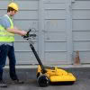
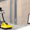
Meet the Leica DS2000 Ground Penetrating Radar
The market for utility locating equipment and ground penetrating radar is evolving. The process of underground utility location, identification and labeling is necessary to increase safety and reduce the risk of accidently damaging buried assets. The traditional way to locate a buried utility is with an electro-magnetic locator but the difficulty with this technology is that… Continue reading Meet the Leica DS2000 Ground Penetrating Radar
Leica Partners With Geolantis Utility Mapping Software
Leica Geosystems have partnered with Geolantis utility mapping software to provide an enterprise-grade solution for Leica detection products. Michael Pegam, CEO of Geolantis says “The combination of Leica Geosystems premium solutions and our cloud based platform is a unique offering. Users around the world benefit from this combination of leading technology, streamlining operations and saving valuable time.… Continue reading Leica Partners With Geolantis Utility Mapping Software