
A city located on a volcanic isthmus, Auckland is home to a large number of dormant and extinct volcanoes. Volcanic cones are quite literally everywhere shaping the landscape of this sprawling city and sitting alongside many seemingly peaceful inner city suburbs. What many of us living in Auckland may not realise is that beneath our… Continue reading Where Art Meets Scanning | Auckland’s Underground Lava Caves [Interview]
Tag: Reality Capture
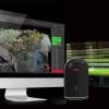
WSP-Opus Adopt Safer Road Scanning With Scan & Go System
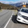
Scanning sections of 100 Km signed highways presents both challenges and risks for surveyors. It would usually require a partial or full road closure and a traffic management plan to minimise the safety issues for both the surveyors and other road users. This was the task facing WSP-Opus on a recent survey project for NZTA… Continue reading WSP-Opus Adopt Safer Road Scanning With Scan & Go System
High Definition Scanning Webinar
![HIGH DEFINITION SCANNING [WEBINAR]](https://staging-globalsurvey.studioeleven.co.nz/wp-content/uploads/2018/01/Webinar-1-Blog-Image-2-100x100.jpg)
** This webinar has already happened but the recording is now available. ** Webinar Recording Available Here You’re invited to attend the first in a series of Leica Geosystems webinars on High Definition Scanning. The first webinar is titled ‘How to Increase Productivity and Collaboration with the Leica Geosystems Total Software Solution’. Learning Objectives: •… Continue reading High Definition Scanning Webinar
New Leica BLK360 Quick To Impress At Harrison Grierson
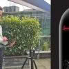
Harrison Grierson are among the first group of NZ companies to secure a new Leica BLK360 imaging scanner and they’ve wasted no time putting their unit to work on multiple projects. As a leading engineering and design firm, Harrison Grierson are known for their forward thinking, innovative approach and depth of expertise. Investing in the… Continue reading New Leica BLK360 Quick To Impress At Harrison Grierson
Leica ScanStation Comparison Chart
The recently released Leica ScanStation P50 offers the highest flexibility for all kinds of scanning projects thanks to its extended range. A longer range ScanStation means less number of setups and reduced field time delivering a quicker return on investment. See our handy Leica ScanStation Comparison Chart to compare the P50, P40 & P30 specifications. MODEL… Continue reading Leica ScanStation Comparison Chart
Congratulations Aurecon!

We’re please to announce that Aurecon are the first company in NZ to receive a Leica BLK360 scanner! The Aurecon NZ team were quick to see the potential of the BLK360 and are keen to start using it across a diverse range of projects. “We’ve got a huge list of projects we want to get… Continue reading Congratulations Aurecon!
Showing Off The BLK360 – BIM Conference
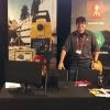
The best BIM minds in the country have converged at NZ’s first dedicated BIM Conference held this week in Auckland. We’re proud to be sponsoring the event and to be able to show off the new Leica BLK360 on our stand. If you’re in attendance come on over and see what all the fuss is… Continue reading Showing Off The BLK360 – BIM Conference
Leica Cyclone REGISTER 360 Released
Leica have just released the new Cyclone REGISTER 360 as an upgrade to Leica Cyclone point cloud registration software. Leica Cyclone REGISTER 360 is available as a stand-alone product or part of the end-to-end Cyclone solution. This is great news for both existing Cyclone users and new users of the Leica BLK360 imaging scanner, now they have simple, guided… Continue reading Leica Cyclone REGISTER 360 Released
Leica BLK360 New Zealand Launch

A big thank you to everyone who attended the official Leica BLK360 launch! It was great to see such a good turn out from new and existing customers who came to learn more about this revolutionary new imaging scanner. After a delicious lunch at Hallertau Brewery, Bruce Robinson presented on the capabilities of the Leica BLK360,… Continue reading Leica BLK360 New Zealand Launch
Cyclone REGISTER 360 Webinar – Maximizing your Registration ROI
Whether you’re an architect, engineer, contractor or surveyor the Leica BLK360 imaging laser scanner along with Leica Cyclone REGISTER 360 software has the power to transform the way you overcome challenges. Leveraging 3D imagery and laser scanning technology has never been easier or more accessible. See just how easy it is to get from field to finished deliverable… Continue reading Cyclone REGISTER 360 Webinar – Maximizing your Registration ROI