What is GPR Ground Penetrating Radar – A geophysical method used to investigate the sub-surface or medium it is applied to. It uses high-frequency electromagnetic waves in the UHF/VHF frequency range of the radio spectrum. These high-frequency signals are transmitted from the system into the ground or medium and the return or reflected signal is… Continue reading Ground Penetrating Radar Explained
Tag: GPR
Aerialsmith Surveying: Seeing Below Ground with Leica GPR
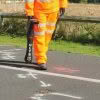
We are in Papatoetoe, South Auckland, with the Aerialsmith Surveying team, who have been tasked with accurately locating the underground services in this area before excavations begin. On this job, they will be using Leica GPR (ground penetrating radar) as the right tool to find all underground assets such as gas, power, water and communications.… Continue reading Aerialsmith Surveying: Seeing Below Ground with Leica GPR
Leica ULTRA | The Ultimate Utility Tracing System
The Leica ULTRA Utility Tracing System delivers accurate and reliable information to protect buried assets and accurately map their location in order to plan for excavation activity. As development of infrastructure in New Zealand has progressed, our network of underground pipes and cables has also expanded and become more complicated. Effective detection and mapping of… Continue reading Leica ULTRA | The Ultimate Utility Tracing System
Ground Penetrating Radar Made Easy | Leica DSX Utility Detection System
Introducing the Leica DSX – an all in one utility detection system designed for non-experienced and first time ground penetrating radar [GPR] users. It is a highly advanced yet easy-to-use solution for locating and mapping buried utilities in a safe, fast and reliable way, without the costs of hiring a specialist. Investing in the Leica… Continue reading Ground Penetrating Radar Made Easy | Leica DSX Utility Detection System
Leica DSX: Reducing the risk of utility strikes [Webinar]

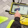
3D utility mapping with the Leica DSX Utility Detection Solution For utility repair and maintenance, civil engineering, geotechnical and surveying companies, the Leica DSX utility detection solution enables easy location, visualisation and mapping of utilities. The Leica DSX solution combines portable hardware with intuitive software and represents a significant change in how Ground Penetrating Radar (GPR) technology… Continue reading Leica DSX: Reducing the risk of utility strikes [Webinar]
Concrete Scanning for Real-Time Data Analysis Onsite
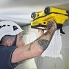
Seeing Through Concrete Structures How can contractors know what lays behind a concrete wall, ceiling or floor? Concrete scanning reveals what’s buried in concrete and is a crucial step in building and construction engineering projects. Knowing the locations of obstacles such as rebars, voids, post-tension cables, cavities, and conduits allows engineers to make better decisions… Continue reading Concrete Scanning for Real-Time Data Analysis Onsite
Aerialsmiths | Pushing the Boundaries with the Latest Technology

Aerialsmiths are a fast growing company based in Auckland that specialise in both land and aerial surveys for earthworks and roading projects. They have a DJI Matrice600 Pro with KLAU PPK drone for aerial surveys and a Leica iCON iCR80 Total Station, Leica GPS60 Rover and Leica DS2000 Ground Penetrating Radar for ground surveys. They… Continue reading Aerialsmiths | Pushing the Boundaries with the Latest Technology
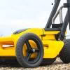
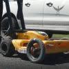
Stream C – Next Level Ground Penetrating Radar
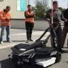
Stream C is a compact array solution for real-time 3D mapping of underground utilities and features. Thanks to increased levels of accuracy provided by a massive antenna array, Stream C Ground Penetrating Radar is able to automatically detect pipes and cables. Stream C Ground Penetrating Radar (GPR) detects underground utilities in real time and quickly produces subsurface GIS-based digital… Continue reading Stream C – Next Level Ground Penetrating Radar
Discover the C-thrue Concrete Scanner

The C-thrue concrete scanner enables you to see through concrete structures and view real-time scan data onsite. Knowing what lies behind concrete before cutting or drilling improves safety and safeguards against the risk of damage. The C-thrue concrete scanner easily locates rebars, voids, post-tension cables, cavities, conduits and any other objects buried in the structure before cutting or drilling… Continue reading Discover the C-thrue Concrete Scanner
GPR Survey at Scott Base, Antarctica
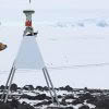
When you’re going to work as a surveyor in Antarctica the number one rule is to be prepared. Preparing for conditions that can get down to -49°C and working outside in weather that can change very quickly is no mean feat. Antarctica New Zealand recently completed a 2 week GPR survey to locate and survey… Continue reading GPR Survey at Scott Base, Antarctica