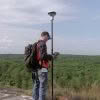
Improving Field Efficiency of Cadastral Surveyors My premise is that greater satellite numbers can dramatically improve field efficiency. Cadastral surveyors typically have a common procedure for minimising the chances of bad GNSS fixes by measuring a survey mark twice. The 2 fixes are typically separated by at least 1 hour to ensure that the GNSS geometry… Continue reading Halving Field Time With Multi-Constellation GNSS [by Bruce Robinson]
Tag: GNSS
Are You Putting Off Equipment Repairs?

Survey and construction equipment is built rugged by design. It has to be tough to withstand the dust, water, and other rigours of use in outdoor construction environments. With that in mind, servicing equipment regularly still plays a large part in ensuring the longevity of it’s working life. To keep your equipment operating accurately and… Continue reading Are You Putting Off Equipment Repairs?
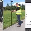
Leica GS18 T | Your Questions Answered

Since its launch, the revolutionary new Leica GS18 T has been making headlines around the world as the greatest innovation for surveyors for years. Here in New Zealand, the geomatics team at Global Survey have been busy with demand for demos from new and existing customers. The new self-calibrating Leica GS18 T with full tilt… Continue reading Leica GS18 T | Your Questions Answered
Beyond The Electronic Bubble | The Leica GS18T Story

The GNSS Evolution This is the story of a decade-long quest for sensor integration, the results of which provide a glimpse into the future of not only GNSS rovers, but also perhaps other surveying and mapping instruments to come. The key differences between Leica Geosystems’ GS18 T tilt compensation and that of many other systems… Continue reading Beyond The Electronic Bubble | The Leica GS18T Story
Leica iCON GPS 70 T – Increased productivity, speed and accuracy
Operate faster, smarter and easier with the new Leica iCON GPS 70 T. Fully calibration-free, the Leica iCON GPS 70 T enables you to operate at maximum efficiency with the latest technology. The ultimate GNSS rover is a fully tilt compensated solution delivering increased productivity onsite. Now you can collect topographic and as-built field data,… Continue reading Leica iCON GPS 70 T – Increased productivity, speed and accuracy
Maximise Your Efficiency. New Leica iCON GPS 70 T

Introducing the new Leica iCON GPS 70 T with full tilt compensation. Fully calibration and interference-free, the iCON GPS 70 T is ready when you are – anytime, anywhere. With the latest innovation in GNSS technology you can now measure and stakeout points quicker than ever before. Collect topographic / as-built field data and stakeout… Continue reading Maximise Your Efficiency. New Leica iCON GPS 70 T
Leica Technology & Northern Corridor Improvements Project

We’re proud to be supplying Leica Geosystems survey technology, software and services to the Northern Corridor Improvements [NCI] project shortly underway on Auckland’s North Shore. The NCI project is a four year programme to build a continuous motorway route from the North Shore to/from the Western Ring Route. It will create a new connection between the Northern Motorway… Continue reading Leica Technology & Northern Corridor Improvements Project
Countdown To NZIS Conference 2018!

We’re counting down the days to the NZIS Conference 2018 on 17th – 19th May at the Rutherford Hotel in Nelson. This year’s conference promises to be bigger and better than ever with 3 days of powerful interactions planned. The event aims to showcase projects and connect members with the skills they need. The event… Continue reading Countdown To NZIS Conference 2018!
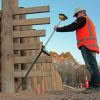
How Much Faster Is The Leica GS18 T?
Setting out with a GNSS antenna requires total concentration. Looking at the instructions and values on the controller screen, moving the pole to the required position, and ensuring the pole is vertical by centering the pole bubble – all at the same time – needs careful execution and is not easy, especially when time pressure… Continue reading How Much Faster Is The Leica GS18 T?
Global Survey Partners With The University Of Waikato

We are honoured to be partnering with The University Of Waikato to ensure their School of Engineering is fully equipped with the latest Leica Geosystems technology. The new fleet of Leica total stations, GNSS smart antennas and Captivate software will be used by students on the new Civil Engineering Programme studying for their Bachelor of Engineering… Continue reading Global Survey Partners With The University Of Waikato