
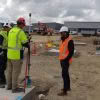
The Leica iCON iCR70 is a construction robotic total station designed to accelerate construction processes onsite and enable you to achieve more in a day. With a bullet-proof set up routine, it provides maximum digital layout efficiency with flexible handling of fully rendered 3D design models in the field. The Leica iCON iCR70 for digital layout… Continue reading Embracing Digital Layout with Leica iCON iCR70
Global Survey News
Leica DSX: Reducing the risk of utility strikes [Webinar]

3D utility mapping with the Leica DSX Utility Detection Solution For utility repair and maintenance, civil engineering, geotechnical and surveying companies, the Leica DSX utility detection solution enables easy location, visualisation and mapping of utilities. The Leica DSX solution combines portable hardware with intuitive software and represents a significant change in how Ground Penetrating Radar (GPR) technology… Continue reading Leica DSX: Reducing the risk of utility strikes [Webinar]
Embracing The No Strings Approach | Hanham & Philp Contractors
Hanham & Philp Contractors are proud of their rich history. Originally founded in 1979 they’ve built up an impressive body of work specialising in commercial buildings, community facilities and heritage renovations. With a staff of around 70, they are well-known in the Canterbury area as leaders in their field. Having been involved with many of… Continue reading Embracing The No Strings Approach | Hanham & Philp Contractors
Concrete Scanning for Real-Time Data Analysis Onsite
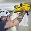
Seeing Through Concrete Structures How can contractors know what lays behind a concrete wall, ceiling or floor? Concrete scanning reveals what’s buried in concrete and is a crucial step in building and construction engineering projects. Knowing the locations of obstacles such as rebars, voids, post-tension cables, cavities, and conduits allows engineers to make better decisions… Continue reading Concrete Scanning for Real-Time Data Analysis Onsite
NEW Leica Nova MS60 MultiStation [Webinar]

The Ultimate All-Rounder – Leica ANZ Webinar Leica Nova MS60 is the world’s first MultiStation and brings sensor fusion to the next level by combining: highest-end total station capabilities, 3D laser scanning, GNSS connectivity and digital imaging to help you perform all required surveying tasks with just one instrument. Demonstrated by using real-life data, Richard… Continue reading NEW Leica Nova MS60 MultiStation [Webinar]
Baldwin Street’s Victory | A Deep Dive into the Laser Scanning Data

When Dunedin’s Baldwin Street lost the Guinness World Record title of “World’s Steepest Street” last year to Ffordd Pen Llech in Wales, Surveyor Toby Stoff immediately thought they must have measured it wrong. “I just looked at it and thought there’s no way that’s steeper than Baldwin Street. Then I noticed they’d measured the Welsh… Continue reading Baldwin Street’s Victory | A Deep Dive into the Laser Scanning Data
WEBINAR: Speed and Collaboration with the BLK2GO

The latest handheld laser scanner, Leica BLK2GO, allows users to seamlessly capture complex spaces in 3D while moving, in real time using SLAM spatial awareness technology. It automatically builds 3D point clouds as you move throughout the entire scan session, which can then be used to join multiple scans, be published to different data formats… Continue reading WEBINAR: Speed and Collaboration with the BLK2GO
Transform Your Digital Delivery | NEW Leica Nova MS60 MultiStation

The all NEW Leica Nova MS60 Multistation has arrived! The new model takes the Leica MS60 to the next level with the addition of several new features which transform this MultiStation into the ultimate all-rounder automatically and continuously adapting to any environment regardless of the challenges. The New Leica Nova MS60 has been improved in… Continue reading Transform Your Digital Delivery | NEW Leica Nova MS60 MultiStation
Designed for Flexibility | Leica Rugby Upgradable Lasers
The revolutionary and unique design of the Leica Rugby Upgradable Lasers enables users to gain maximum performance and functionality without the need to purchase a separate model in the future. Leica Rugby Upgradable Lasers are also designed for superior durability, ease of use, and rugged performance on construction sites. Designed for Simplicity Leica Rugby Upgradable… Continue reading Designed for Flexibility | Leica Rugby Upgradable Lasers
eBee X Survey Drone: Maximise Your Aerial Mapping Efficiency
The senseFly eBee X survey drone should be added to every aerial surveyor’s toolkit! Its fixed-wing design with high spec features provide an all-in-one solution to everyday aerial surveying needs. It is designed to deliver maximum efficiency by addressing common issues such as time constraints, weather predicaments and safer access to job sites. Complete… Continue reading eBee X Survey Drone: Maximise Your Aerial Mapping Efficiency