When people say ‘Reality Capture’ they often mean devices that produce point clouds. But, at a fundamental level, Reality Capture is capturing the real world and creating a 3D digital representation of it. Isn’t this what Surveyors have been doing since day one? Newer reality capture methods, like terrestrial laser scanning (TLS) and photogrammetry, have… Continue reading Reality Capture is not a new concept
Global Survey News
Otago University School of Surveying now equipped with Leica TS10 total stations
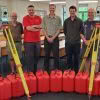
Students at Otago University School of Surveying are now benefitting further from Leica instruments and workflows, following the acquisition of 10 brand new Leica TS10 Total Stations. Richard Harrison from our Christchurch office personally delivered the new equipment and spent time setting up the instruments for the needs of the University, he’ll also be providing… Continue reading Otago University School of Surveying now equipped with Leica TS10 total stations
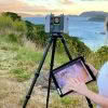
Envelope: Overcoming surveying challenges with the Leica GS18I
We’re high up in the hills above Ōwhiro Bay in Wellington with the Envelope survey team as they work with Zipline Technologies to help deliver a project that will result in four ziplines and extensive walking tracks throughout the regenerated native bush. As part of this project, the Envelope survey team are tasked with capturing… Continue reading Envelope: Overcoming surveying challenges with the Leica GS18I
Custom Rapid Deployment Monitoring Solutions
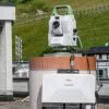
The Global Survey Geomatics team have recently been involved with setting up solutions for monitoring projects. Monitoring projects are often long-term by nature and planned over a period of weeks or months, and usually involve a significant investment in time, equipment, software and expertise. Often they remain in place over many years and as a… Continue reading Custom Rapid Deployment Monitoring Solutions
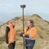
Investing in the Next Generation of University of Otago Survey School Graduates
The Global Survey team recently ran two workshops for the final year students at University of Otago Survey School. From a practical perspective the plan was to demonstrate how the latest technologies are able to make graduates more productive and efficient for when they enter the work force at the end of their current year… Continue reading Investing in the Next Generation of University of Otago Survey School Graduates
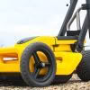
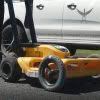
How does an Engcon Tiltrotator Improve Your Business?

Over the last decade, tiltrotators have taken the world by storm and it’s easy to see why! Their versatility makes them a must have piece of kit in many regions across Europe, Scandinavia and the US. Engcon are a global leading brand based in Sweden and are the largest manufacturer of tiltrotators in the world,… Continue reading How does an Engcon Tiltrotator Improve Your Business?
Ground Penetrating Radar Explained
What is GPR Ground Penetrating Radar – A geophysical method used to investigate the sub-surface or medium it is applied to. It uses high-frequency electromagnetic waves in the UHF/VHF frequency range of the radio spectrum. These high-frequency signals are transmitted from the system into the ground or medium and the return or reflected signal is… Continue reading Ground Penetrating Radar Explained
Global Survey appointed as new Xwatch dealer in New Zealand!
Global Survey have been appointed as a new dealer for Xwatch safety solutions. Xwatch XW range includes a variety of systems designed to add an extra layer of safety for excavators with height and slew limiters and rated capacity indicator (RCI). Xwatch technology is designed and manufactured in the UK using only the highest quality… Continue reading Global Survey appointed as new Xwatch dealer in New Zealand!
MetaConnex – connecting survey metadata to the latest 12d Model tool
The modern practice of exporting Leica survey data uses stylesheets to create 12d field files. This export method allows all the survey metadata captured in the field to be utilised in 12d. The whole process from capture through to design focuses on minimal manual metadata entry and provides a high level of quality assurance. This… Continue reading MetaConnex – connecting survey metadata to the latest 12d Model tool
Aerialsmith Surveying: Seeing Below Ground with Leica GPR
We are in Papatoetoe, South Auckland, with the Aerialsmith Surveying team, who have been tasked with accurately locating the underground services in this area before excavations begin. On this job, they will be using Leica GPR (ground penetrating radar) as the right tool to find all underground assets such as gas, power, water and communications.… Continue reading Aerialsmith Surveying: Seeing Below Ground with Leica GPR