As the construction industry becomes more digital, there is a requirement to be more efficient in construction layout to complete projects on time and under budget. The new Leica iCON iCB manual construction total stations aid this shift to digitalisation, allowing field crews to work directly with digital design data, layout complex structures with improved… Continue reading Leica iCON Total Station Comparison Chart
Global Survey News
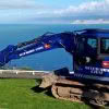
Aerialsmiths | Pushing the Boundaries with the Latest Technology

Aerialsmiths are a fast growing company based in Auckland that specialise in both land and aerial surveys for earthworks and roading projects. They have a DJI Matrice600 Pro with KLAU PPK drone for aerial surveys and a Leica iCON iCR80 Total Station, Leica GPS60 Rover and Leica DS2000 Ground Penetrating Radar for ground surveys. They… Continue reading Aerialsmiths | Pushing the Boundaries with the Latest Technology
S+S NZ Engineering & Positioning Workshop

We’re proud to continue our support of the industry as Diamond Partners of S+SNZ. Join us at the upcoming Survey & Spatial New Zealand Engineering & Positioning Workshop where professionals from the surveying and engineering industries will be sharing knowledge and showcasing projects that use innovative technology. Our team will be there discussing some of… Continue reading S+S NZ Engineering & Positioning Workshop
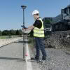
Leica PA10 Personal Alert System | Keeping Your Most Important Assets Safe Onsite
Leica PA10 Personal Alert System – Minimise Vehicle Related Incidents Any Health & Safety Manager will tell you that the nature of work in the construction industry means it is a relatively high-risk industry. Construction sites can be dangerous – heavy traffic, large equipment, poor visibility and blind spots all create the potential for accidents onsite.… Continue reading Leica PA10 Personal Alert System | Keeping Your Most Important Assets Safe Onsite
Smart Christchurch – Mobile Mapping with the Leica Pegasus: Two

The Global Survey team will be exhibiting at next week’s Smart Christchurch Innovation Expo alongside Christchurch City Council. We’ll be showcasing the latest Leica Geosystems reality capture technology including the Leica Pegasus: Two Mobile Mapper which is currently being trialled as part of the Smart Christchurch initiative. The Innovation Expo is organised by the Christchurch… Continue reading Smart Christchurch – Mobile Mapping with the Leica Pegasus: Two
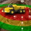
Siteworx Civil | Boosting Productivity with Leica iCON Machine Control
With a rich 50 year history, family owned and operated Siteworx Civil have a stand out reputation as one of the leading civil construction companies in the East Cape. If you’ve spent any time in the Gisborne area you’ve probably already seen Siteworx Civil in action, their distinctive blue Volvo excavators are hard to miss!… Continue reading Siteworx Civil | Boosting Productivity with Leica iCON Machine Control
Welcome To The Team Nico Prins!

We are pleased to announce the appointment of Nico Prins as Machine Control Installation & Support Technician. Nico brings a wealth of experience to the role, having worked in the Construction industry for almost 30 years and more recently specialising in machine control guidance, maintenance and support. He is already very familiar with the Leica… Continue reading Welcome To The Team Nico Prins!
Leica & Autodesk | Bridging the Information Gap

Global industry partners Leica Geosystems and Autodesk have been working closely together to help close the information loop between design office and site. Leica offers a range of comprehensive set out solutions for both the survey and construction industries. Leica iCON Build and iCON Site are primarily targeted towards the vertical/horizontal construction markets, whereas, Leica… Continue reading Leica & Autodesk | Bridging the Information Gap
Leica Laser Scanning | Accurately Measuring Baldwin Street’s Steepness
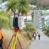
Iconic Baldwin Street in Dunedin recently lost the Guinness World Record title of “World’s Steepest Street” to Ffordd Pen Llech in the village of Harlech, Wales. Dunedin based Surveyor, Toby Stoff from Clark Fortune McDonald, has made national and international headlines with his claims that the Welsh street was measured inaccurately and therefore is not… Continue reading Leica Laser Scanning | Accurately Measuring Baldwin Street’s Steepness
GNSS Smart Antenna Comparison Chart
Are you unsure about which Leica GNSS antenna is right for the job? The handy comparison chart shows the main difference in specification between the Leica GS07, GS14, GS16 and GS18 T GNSS Antennas. ANTENNA LEICA GS07 LEICA GS14 LEICA GS16 LEICA GS18 T SIGNAL TRACKING Multi-frequency Dual-frequency Multi-frequency Multi-frequency GPS / GLONASS / GALILEO… Continue reading GNSS Smart Antenna Comparison Chart