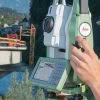
Flexline with AutoHeight are the newest generation of total stations from Leica Geosystems, they replace the former FlexLine instruments that were launched more than a decade ago. In this interview, Hans Martin Zogg, Business Director for total stations, explains what’s new with the latest Leica FlexLine total stations. What’s New With Leica’s Latest Total Stations?… Continue reading Expert Insights: What’s new with Leica FlexLine Total Stations?
Category: Surveying & GIS News
Checking the Status of a SmartFix Reference Station

If you are experiencing problems connecting to Mountpoint in the field [or the office] it is good to be able to identify where the problem could be. The first step in identifying a problem is to confirm whether the SmartFix Reference Station you have connected to is actually available for use. To check this you… Continue reading Checking the Status of a SmartFix Reference Station
Leica RTC360 Laser Scanner & Collision Investigations
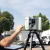
When your crime scene is situated in the middle of a busy intersection in one of LA’s most densely populated cities, you need a fast laser scanning solution. “It can get pretty dicey out there,” says Investigator Weston Hadley, of the Santa Ana Police Department’s Collision Investigations Unit. Until recently, Hadley and his fellow investigators… Continue reading Leica RTC360 Laser Scanner & Collision Investigations
Faster Outdoor Reality Capture with Scan & Go
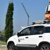
The Scan & Go system is a vehicle-mounted, elevated platform for outdoor laser scanning projects. It is self-leveling, compatible with all makes and models of laser scanners and easily mounted on top of any vehicle. With a growing demand for large volumes of 3D data acquisition, the Scan & Go system delivers extraordinary performance for… Continue reading Faster Outdoor Reality Capture with Scan & Go
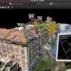
Leica HDS: Reality Capture Software Explained

Leica Geosystems is the market-leader in point cloud delivery solutions. We offer a family of hardware and software that provides the widest set of work process options for 3D laser scanning projects in engineering, surveying, construction and related applications. Model and share your point cloud data with end-to-end Leica HDS solutions. From data collection to… Continue reading Leica HDS: Reality Capture Software Explained
Downer NZ Invests in Leica Mobile Mapper
We’re pleased to announce that Downer NZ have secured New Zealand’s first Leica Pegasus: Two [Ultimate] Mobile Mapper. The revolutionary Pegasus: Two captures spatial data using a combination of Inertial Measurement Unit [IMU], cameras, GPS and laser profiling technology delivering geo-referenced data for multiple applications. A key benefit is the Pegasus: Two’s ability is to… Continue reading Downer NZ Invests in Leica Mobile Mapper
Survey & Spatial NZ Annual Conference 2019

Are you attending this year’s Survey & Spatial NZ Annual Conference? Later this week we’ll be celebrating 130 years of the association in NZ and we’re proud to have been involved for several of those decades, more recently as a Diamond Partner, actively supporting NZ Surveyors and the industry. The Conference is a must attend… Continue reading Survey & Spatial NZ Annual Conference 2019
Leica HDS Webinar #2: What to consider for your QA/QC workflows in Cyclone REGISTER 360
Join us for the second in our series of HDS webinars designed specifically for Leica users across Australia & New Zealand: Webinar #2: What to consider for your QA/QC workflows in Cyclone REGISTER 360 This webinar discusses the fundamental QA/QC processes in Cyclone REGISTER 360 and demonstrates methods of combining pre-registered and unregistered project data.… Continue reading Leica HDS Webinar #2: What to consider for your QA/QC workflows in Cyclone REGISTER 360
Stream C – Next Level Ground Penetrating Radar
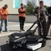
Stream C is a compact array solution for real-time 3D mapping of underground utilities and features. Thanks to increased levels of accuracy provided by a massive antenna array, Stream C Ground Penetrating Radar is able to automatically detect pipes and cables. Stream C Ground Penetrating Radar (GPR) detects underground utilities in real time and quickly produces subsurface GIS-based digital… Continue reading Stream C – Next Level Ground Penetrating Radar
KiwiRail Survey Kaikoura’s Main North Line
Recovering from the 7.8 magnitude Kaikoura earthquake of November 2016 has been a long time coming for those effected. Along with widespread devastation of homes and businesses in the region, the earthquake also ripped through the main transport routes that linked Kaikoura to Picton and Christchurch, closing SH1 and pushing the Main North railway line… Continue reading KiwiRail Survey Kaikoura’s Main North Line