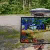
Have you ever been onsite, looking at the ground and thought “This would be so much easier if I could open up that trench again and take another look”. Ever been in the position where you’re looking at 2d plans and trying to imagine what the roofline will be like in reality? Or maybe you… Continue reading How would vGIS improve the way you work?
Category: Surveying & GIS News
The Digital Shipyard [Webinar]
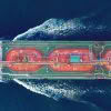
How 3D laser scanning and advanced manufacturing technologies drive efficiency and profitability in the shipbuilding industry Safety, efficient resource management and output are key concerns for the shipbuilding industry. A more progressive approach to tackling design, assembly, fabrication, construction, and operation and maintenance involves the application of 3D laser scanning and advanced manufacturing technology to… Continue reading The Digital Shipyard [Webinar]
Expand Your Project Capabilities: A Surveyors’ Guide to Fixed-Wing Drones [Webinar]
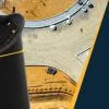
As a professional surveyor, the equipment you take to the field is just as important as the data you bring back to the office. But how you collect your data can have a big impact on your ability to complete projects quickly, efficiently and with the required data quality. That’s why thousands of surveyors are… Continue reading Expand Your Project Capabilities: A Surveyors’ Guide to Fixed-Wing Drones [Webinar]
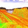
Why we chose the eBee X Survey Drone [Interview]
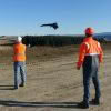
We sat down with Jordan Whyte, Senior Mine Surveyor at Oceana Gold, to find out how their Surveyors are using drone technology and why they chose the eBee X Survey Drone. GS: Can you give us an overview of the Macraes Operation? Jordan: The Macraes Gold Mine site in New Zealand’s South Island is the… Continue reading Why we chose the eBee X Survey Drone [Interview]
Case Study: Our Scan to BIM Journey
Our Auckland office recently moved to a new building to give us the extra space we needed as the company continues to grow. This move offered a unique opportunity for us to practice what we preach and put our digital solutions to work! Although our office move was only 500m up the road, the task… Continue reading Case Study: Our Scan to BIM Journey
Central Interceptor Project | Inspecting Surfaces with the New Leica MS60
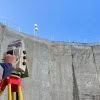
The Watercare Central Interceptor Project in Auckland has reached an exciting stage as the team prepare for the arrival of Hiwa-i-te-Rangi their giant new Tunnel Boring Machine [TBM] which is currently being built in Germany. The main contractor Ghella Abergeldie Joint Venture are building the Central Interceptor over six years with most of the construction… Continue reading Central Interceptor Project | Inspecting Surfaces with the New Leica MS60
Sub-Millimetre Accuracy with Leica Absolute Laser Trackers
A long-term standard in Industrial Metrology, Leica Absolute Laser Trackers lead the field in terms of the accuracy, reliability and durability of portable coordinate measuring machines. Surveyors would recognise these machines as Total Stations, but with the distinction of being capable of measuring large objects to sub millimetre accuracy. Leica Absolute Laser Trackers measure distances… Continue reading Sub-Millimetre Accuracy with Leica Absolute Laser Trackers
Public Safety in the age of Reality Capture [Webinar]

Discover how to leverage the latest advancements in reality capture technology in this webinar from Leica Geosystems: “Public Safety in the age of Reality Capture” As police and security departments around the world have rapidly added reality capture technology to their scene recording tool-set, Leica has continued to innovate to support the unique workflows and… Continue reading Public Safety in the age of Reality Capture [Webinar]
Digitally Preserving NZ’s Maritime History with the Leica RTC360
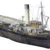
When you are involved in laser scanning you see the world differently. We get excited about unusual and interesting structures and often think “That would be amazing to scan!”. Few structures are more complex or intricate than maritime vessels, so when Lennon Bedford & Richard Harrison from our Christchurch team saw the historic Tug Lyttelton,… Continue reading Digitally Preserving NZ’s Maritime History with the Leica RTC360
Vitruvius utilise Leica Laser Scanning Technology for Northland’s Rail Upgrade
Upgrading Northland’s Rail Network The first section of track on the historic North Auckland Line (NAL) was opened in 1868 and the line was finally completed in full in 1925. NAL begins at Westfield in Auckland and runs for over 280km before terminating at Otiria in Northland. With many NAL assets nearing their ‘end of… Continue reading Vitruvius utilise Leica Laser Scanning Technology for Northland’s Rail Upgrade