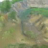
3D terrain mapping with drones has become common practice over the last decade. Relatively low-cost drones combined with autonomous mission planning apps and user-friendly photogrammetry software (such as ContextCapture and Leica Infinity amongst others) have provided highly efficient workflows for building accurate and complete 3D models of terrain more quickly and safely than traditional ‘boots… Continue reading Introducing the CHC AlphaAir 450 LiDAR: Smaller, lighter sensor for Drone Surveying
Category: Surveying & GIS News
Abley: Optimising augmented reality in construction with vGIS

The recent industry survey by Deloitte for Autodesk “The state of digital adoption in construction report 2023” showed that businesses using digital technologies are more likely to be successful across a number of measures including revenue growth and optimism about the future. The adoption of digital technologies under an organisation-wide strategy that includes training and… Continue reading Abley: Optimising augmented reality in construction with vGIS
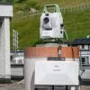
McLeod Cranes: Cleaning up the Waikato Te Awa river with the Leica RTC360
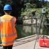
Did you know there are approximately 200 cars on the bottom of the Waikato Te Awa River? The Leica RTC360, a 230 tonne crane and bathymetric sonar have all been key elements in the cleanup efforts of this debris. It’s a picture perfect autumn day in the Waikato as we join the McLeod Cranes team… Continue reading McLeod Cranes: Cleaning up the Waikato Te Awa river with the Leica RTC360
Reality Capture is not a new concept
When people say ‘Reality Capture’ they often mean devices that produce point clouds. But, at a fundamental level, Reality Capture is capturing the real world and creating a 3D digital representation of it. Isn’t this what Surveyors have been doing since day one? Newer reality capture methods, like terrestrial laser scanning (TLS) and photogrammetry, have… Continue reading Reality Capture is not a new concept
Otago University School of Surveying now equipped with Leica TS10 total stations
Students at Otago University School of Surveying are now benefitting further from Leica instruments and workflows, following the acquisition of 10 brand new Leica TS10 Total Stations. Richard Harrison from our Christchurch office personally delivered the new equipment and spent time setting up the instruments for the needs of the University, he’ll also be providing… Continue reading Otago University School of Surveying now equipped with Leica TS10 total stations
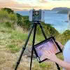
Envelope: Overcoming surveying challenges with the Leica GS18I
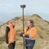
We’re high up in the hills above Ōwhiro Bay in Wellington with the Envelope survey team as they work with Zipline Technologies to help deliver a project that will result in four ziplines and extensive walking tracks throughout the regenerated native bush. As part of this project, the Envelope survey team are tasked with capturing… Continue reading Envelope: Overcoming surveying challenges with the Leica GS18I
Custom Rapid Deployment Monitoring Solutions
The Global Survey Geomatics team have recently been involved with setting up solutions for monitoring projects. Monitoring projects are often long-term by nature and planned over a period of weeks or months, and usually involve a significant investment in time, equipment, software and expertise. Often they remain in place over many years and as a… Continue reading Custom Rapid Deployment Monitoring Solutions
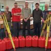
Investing in the Next Generation of University of Otago Survey School Graduates
The Global Survey team recently ran two workshops for the final year students at University of Otago Survey School. From a practical perspective the plan was to demonstrate how the latest technologies are able to make graduates more productive and efficient for when they enter the work force at the end of their current year… Continue reading Investing in the Next Generation of University of Otago Survey School Graduates
MetaConnex – connecting survey metadata to the latest 12d Model tool
The modern practice of exporting Leica survey data uses stylesheets to create 12d field files. This export method allows all the survey metadata captured in the field to be utilised in 12d. The whole process from capture through to design focuses on minimal manual metadata entry and provides a high level of quality assurance. This… Continue reading MetaConnex – connecting survey metadata to the latest 12d Model tool
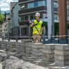
Maven: Saving Time with Leica Captivate SmartPole
Having worked on some of New Zealand’s largest and most complex residential, commercial and public sector projects, Maven have a focus on delivering excellence for their clients. One of the ways they achieve this is by utilising the latest technology in order to work as productively and efficiently as possible. They have a well-established network of… Continue reading Maven: Saving Time with Leica Captivate SmartPole