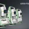
The new Leica FlexLine Series; TS03, TS07 and TS10 manual total stations were launched last week at INTERGEO in Frankfurt, Germany. Building on the FlexLine series legacy of quality, durability and low total cost of ownership, the new Leica FlexLine manual total stations are designed to improve productivity in the field by automatically capturing height. World’s… Continue reading New Leica FlexLine Series with AutoHeight
Category: Surveying & GIS News
Want A Sneak Peek At The New Leica BLK3D?

If you’re an AEC professional that’s been eagerly awaiting the arrival of the new Leica BLK3D, this is your chance to see it in action before the product is even released! We are pleased to announce that the Leica BLK3D will be joining us for the first time in New Zealand at the upcoming BIM… Continue reading Want A Sneak Peek At The New Leica BLK3D?
Increase your efficiency with Leica equipment hire
Hiring construction and survey equipment can be the perfect solution if you need a specific instrument short-term or if you want to try the latest technology in the field for an extended period of time. Leica equipment hire is a good option if the job is starting soon and you need the equipment calibrated and… Continue reading Increase your efficiency with Leica equipment hire
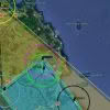
Halving Field Time With Multi-Constellation GNSS [by Bruce Robinson]
Improving Field Efficiency of Cadastral Surveyors My premise is that greater satellite numbers can dramatically improve field efficiency. Cadastral surveyors typically have a common procedure for minimising the chances of bad GNSS fixes by measuring a survey mark twice. The 2 fixes are typically separated by at least 1 hour to ensure that the GNSS geometry… Continue reading Halving Field Time With Multi-Constellation GNSS [by Bruce Robinson]
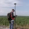
New SmartFix Reference Stations in the North Island
It is exciting to be able to continue to grow the SmartFix reference station network. In the last few weeks two new stations have been made active in Kerikeri (GSKK) and Whangarei (GSWR). The GSWR has been established to help overcome some of the problems associated with the location where WHNG is located. There are… Continue reading New SmartFix Reference Stations in the North Island
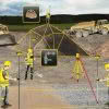
Where Art Meets Scanning | Auckland’s Underground Lava Caves [Interview]
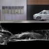
A city located on a volcanic isthmus, Auckland is home to a large number of dormant and extinct volcanoes. Volcanic cones are quite literally everywhere shaping the landscape of this sprawling city and sitting alongside many seemingly peaceful inner city suburbs. What many of us living in Auckland may not realise is that beneath our… Continue reading Where Art Meets Scanning | Auckland’s Underground Lava Caves [Interview]
Get the most out of your Leica BLK360 [Webinar]
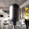
** This webinar has already happened but the recording is now available. ** Webinar Recording Available Here Get the most out of your Leica BLK360: Deliver meaningful information The BLK360 is proving to be versatile across many applications and industries. At the touch of a button, you can capture 3D point cloud data at 360,000… Continue reading Get the most out of your Leica BLK360 [Webinar]
Are You Putting Off Equipment Repairs?
Survey and construction equipment is built rugged by design. It has to be tough to withstand the dust, water, and other rigours of use in outdoor construction environments. With that in mind, servicing equipment regularly still plays a large part in ensuring the longevity of it’s working life. To keep your equipment operating accurately and… Continue reading Are You Putting Off Equipment Repairs?
New Zealand BIM Conference 2018

After an incredible launch event last year the New Zealand BIM Conference 2018 is set to be bigger and better in 2018. The BIM Conference is an opportunity for construction sector professionals to engage and collaborate on the uptake of BIM across New Zealand. This year, our BIM specialist Tim Jervis will be speaking on “The Evolution of Reality… Continue reading New Zealand BIM Conference 2018
Leica GS18 T | Your Questions Answered
Since its launch, the revolutionary new Leica GS18 T has been making headlines around the world as the greatest innovation for surveyors for years. Here in New Zealand, the geomatics team at Global Survey have been busy with demand for demos from new and existing customers. The new self-calibrating Leica GS18 T with full tilt… Continue reading Leica GS18 T | Your Questions Answered