
SmartFix New Ports Opened to Ensure Coordinate Alignment with LINZ SmartFix site coordinates are now calculated as part of the National adjustment. This ensures the SmartFix reference stations’ status as 3rd order marks. In order for your rover to stay aligned you need to transition to the new ports. The Port number is the key to… Continue reading SmartFix New Ports: Important Update
Author: TR
Nulca NZ Launch Event!
We’re proud to sponsor the launch of the National Utility Locating Contractors Association [Nulca]. This is New Zealand’s only industry association representing the interests of the utility location industry. The objective of Nulca NZ is to support and grow the capabilities of individuals and organisations involved in locating, tracing and mapping underground services. Their mission… Continue reading Nulca NZ Launch Event!
Welcome To Sales Andrew Browning!

We’re pleased to announce the appointment of Andrew Browning to the role of Machine Control Sales Consultant. Andrew joined Global Survey 18 months ago as a Machine Control Installer. His extensive product knowledge and enthusiasm for the Leica iCON range mean he’s ahead of the curve as he is promoted to our Machine Control Sales… Continue reading Welcome To Sales Andrew Browning!
Checking the Status of a SmartFix Reference Station
If you are experiencing problems connecting to Mountpoint in the field [or the office] it is good to be able to identify where the problem could be. The first step in identifying a problem is to confirm whether the SmartFix Reference Station you have connected to is actually available for use. To check this you… Continue reading Checking the Status of a SmartFix Reference Station
Leica MC1 – One Common Platform, One Panel, Multiple Machines
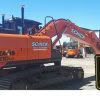
The new Leica MC1 solution consists of a state-of-the-art MCP80 control panel combined with next generation machine control software. Leica Geosystems delivers an intelligent and intuitive hardware and software combination. Leica MC1 solution offers a unified hardware platform with common software interface, across multiple machines that integrates seamlessly with the Leica iCON suite of products. Leica… Continue reading Leica MC1 – One Common Platform, One Panel, Multiple Machines
Leica HDS: Reality Capture Software Explained

Leica Geosystems is the market-leader in point cloud delivery solutions. We offer a family of hardware and software that provides the widest set of work process options for 3D laser scanning projects in engineering, surveying, construction and related applications. Model and share your point cloud data with end-to-end Leica HDS solutions. From data collection to… Continue reading Leica HDS: Reality Capture Software Explained
Downer NZ Invests in Leica Mobile Mapper

We’re pleased to announce that Downer NZ have secured New Zealand’s first Leica Pegasus: Two [Ultimate] Mobile Mapper. The revolutionary Pegasus: Two captures spatial data using a combination of Inertial Measurement Unit [IMU], cameras, GPS and laser profiling technology delivering geo-referenced data for multiple applications. A key benefit is the Pegasus: Two’s ability is to… Continue reading Downer NZ Invests in Leica Mobile Mapper
Discover the C-thrue Concrete Scanner

The C-thrue concrete scanner enables you to see through concrete structures and view real-time scan data onsite. Knowing what lies behind concrete before cutting or drilling improves safety and safeguards against the risk of damage. The C-thrue concrete scanner easily locates rebars, voids, post-tension cables, cavities, conduits and any other objects buried in the structure before cutting or drilling… Continue reading Discover the C-thrue Concrete Scanner
KiwiRail Survey Kaikoura’s Main North Line
Recovering from the 7.8 magnitude Kaikoura earthquake of November 2016 has been a long time coming for those effected. Along with widespread devastation of homes and businesses in the region, the earthquake also ripped through the main transport routes that linked Kaikoura to Picton and Christchurch, closing SH1 and pushing the Main North railway line… Continue reading KiwiRail Survey Kaikoura’s Main North Line
Lava Cave Mapping with the Leica BLK360
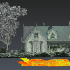
The landscape of Auckland has been primarily shaped by historic volcanic activity. A sprawling city located in an isthmus, home to a network of over 50 dormant and extinct volcanoes. Numerous above ground volcanic cones are prominent features of the city’s skyline, but what many residents don’t realise is that beneath the ground hides a… Continue reading Lava Cave Mapping with the Leica BLK360