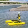
Seafloor Systems are continuing to develop and improve their hydrographic surveying solutions, including the popular EchoBoat and HydroCat systems. As an affordable and effective surveying platform, these systems are highly versatile and can be customised to suit individual, environmental and project requirements. Unmanned Surface Vessels (USVs) are commonly used by Surveyors to overcome access challenges,… Continue reading Everything you need to know about Unmanned Surface Vessels from Seafloor Systems
Author: TR
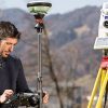
McLeod Cranes: Cleaning up the Waikato Te Awa river with the Leica RTC360
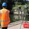
Did you know there are approximately 200 cars on the bottom of the Waikato Te Awa River? The Leica RTC360, a 230 tonne crane and bathymetric sonar have all been key elements in the cleanup efforts of this debris. It’s a picture perfect autumn day in the Waikato as we join the McLeod Cranes team… Continue reading McLeod Cranes: Cleaning up the Waikato Te Awa river with the Leica RTC360
Reality Capture is not a new concept
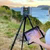
When people say ‘Reality Capture’ they often mean devices that produce point clouds. But, at a fundamental level, Reality Capture is capturing the real world and creating a 3D digital representation of it. Isn’t this what Surveyors have been doing since day one? Newer reality capture methods, like terrestrial laser scanning (TLS) and photogrammetry, have… Continue reading Reality Capture is not a new concept
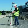
Envelope: Overcoming surveying challenges with the Leica GS18I
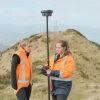
We’re high up in the hills above Ōwhiro Bay in Wellington with the Envelope survey team as they work with Zipline Technologies to help deliver a project that will result in four ziplines and extensive walking tracks throughout the regenerated native bush. As part of this project, the Envelope survey team are tasked with capturing… Continue reading Envelope: Overcoming surveying challenges with the Leica GS18I
Accelerate data transfer from field to office with Leica Exchange

Leica Exchange optimises your precious time and expenses by providing a fast and secure method to transfer data from Leica Captivate straight from the field to your office. Eliminate the need for long travel times and fumbling around with USBs! This service enables you to send data directly in various ways: ✓ Between users in your… Continue reading Accelerate data transfer from field to office with Leica Exchange
How To Use Stylesheets with Leica Captivate & Leica Infinity File Export Formats
Global Survey customers can benefit from our development of several New Zealand based stylesheets to work with Leica Captivate and Leica Infinity file export formats. Leica Captivate software supports the export of data in multiple formats for various requirements. Below are the supported formats for export and the differences between them. ASCII with format file… Continue reading How To Use Stylesheets with Leica Captivate & Leica Infinity File Export Formats
Taggart: Embracing Leica Semi-Auto Machine Control

Contractor profile: Taggart On the outskirts of Christchurch, the earthworks for the Ravenswood subdivision stage 3 are underway. Taggart are the main contractor, tasked with transforming this section of the project into a subdivision for 200 family homes. WATCH: Onsite with Taggart and their Semi-Auto Excavator We arrive onsite on a stunning Christchurch winter day,… Continue reading Taggart: Embracing Leica Semi-Auto Machine Control
Survey Regulation Change: Cadastral Field Notes
New Zealand Surveyors should be aware and prepared for the upcoming change in Survey regulations that will require Field Notes to be submitted with a Cadastral dataset. Global Survey have developed stylesheets (in discussion with LINZ) to support this upcoming change in regulations. Survey jobs can either be exported directly from Leica Captivate or Viva… Continue reading Survey Regulation Change: Cadastral Field Notes
What’s The Difference Between Leica RTC360 and RTC360 LT?
The Leica RTC360 is a first-class laser scanning powerhouse that was announced in 2018 to outstanding reception. It helped to maximise productivity and efficiency for construction professionals, delivering time-saving and highly accurate 3D capture results. Since its launch, the Leica RTC360 has led the market as the world’s fastest laser scanner. In a nutshell, it’s… Continue reading What’s The Difference Between Leica RTC360 and RTC360 LT?
WG de Gruchy Construction: Where Traditional Meets Digital Building Methods

We meet Willie de Gruchy onsite in Auckland’s prestigious Remuera, his current project is still in the early stages of the build, the earthworks are almost done and the internal lap pool has just taken shape. The site is tidy, everything has a place and multi-coloured string lines mark out the various features of this… Continue reading WG de Gruchy Construction: Where Traditional Meets Digital Building Methods