
Introducing iCON Site Field Software. Time and costs are constant pressures on the modern work site with the knock on effect of making productivity paramount and multi-skilled personnel key to improving efficiency. Some tasks which were previously conducting solely by surveyors are now being done by site workers to save time and minimise delays. The Leica iCON Site… Continue reading Digitising Construction Workflows with Leica iCON Site
Author: StudioEleven
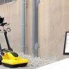
Meet the Leica DS2000 Ground Penetrating Radar
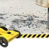
The market for utility locating equipment and ground penetrating radar is evolving. The process of underground utility location, identification and labeling is necessary to increase safety and reduce the risk of accidently damaging buried assets. The traditional way to locate a buried utility is with an electro-magnetic locator but the difficulty with this technology is that… Continue reading Meet the Leica DS2000 Ground Penetrating Radar
Leica Partners With Geolantis Utility Mapping Software
Leica Geosystems have partnered with Geolantis utility mapping software to provide an enterprise-grade solution for Leica detection products. Michael Pegam, CEO of Geolantis says “The combination of Leica Geosystems premium solutions and our cloud based platform is a unique offering. Users around the world benefit from this combination of leading technology, streamlining operations and saving valuable time.… Continue reading Leica Partners With Geolantis Utility Mapping Software