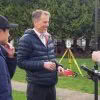
The Global Survey team recently ran two workshops for the final year students at University of Otago Survey School. From a practical perspective the plan was to demonstrate how the latest technologies are able to make graduates more productive and efficient for when they enter the work force at the end of their current year… Continue reading Investing in the Next Generation of University of Otago Survey School Graduates
Author: Anya van Oudtshoon
How does an Engcon Tiltrotator Improve Your Business?

Over the last decade, tiltrotators have taken the world by storm and it’s easy to see why! Their versatility makes them a must have piece of kit in many regions across Europe, Scandinavia and the US. Engcon are a global leading brand based in Sweden and are the largest manufacturer of tiltrotators in the world,… Continue reading How does an Engcon Tiltrotator Improve Your Business?
Ground Penetrating Radar Explained

What is GPR Ground Penetrating Radar – A geophysical method used to investigate the sub-surface or medium it is applied to. It uses high-frequency electromagnetic waves in the UHF/VHF frequency range of the radio spectrum. These high-frequency signals are transmitted from the system into the ground or medium and the return or reflected signal is… Continue reading Ground Penetrating Radar Explained
Global Survey appointed as new Xwatch dealer in New Zealand!

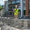
Global Survey have been appointed as a new dealer for Xwatch safety solutions. Xwatch XW range includes a variety of systems designed to add an extra layer of safety for excavators with height and slew limiters and rated capacity indicator (RCI). Xwatch technology is designed and manufactured in the UK using only the highest quality… Continue reading Global Survey appointed as new Xwatch dealer in New Zealand!
MetaConnex – connecting survey metadata to the latest 12d Model tool
The modern practice of exporting Leica survey data uses stylesheets to create 12d field files. This export method allows all the survey metadata captured in the field to be utilised in 12d. The whole process from capture through to design focuses on minimal manual metadata entry and provides a high level of quality assurance. This… Continue reading MetaConnex – connecting survey metadata to the latest 12d Model tool
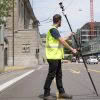
Aerialsmith Surveying: Seeing Below Ground with Leica GPR
We are in Papatoetoe, South Auckland, with the Aerialsmith Surveying team, who have been tasked with accurately locating the underground services in this area before excavations begin. On this job, they will be using Leica GPR (ground penetrating radar) as the right tool to find all underground assets such as gas, power, water and communications.… Continue reading Aerialsmith Surveying: Seeing Below Ground with Leica GPR
Maven: Saving Time with Leica Captivate SmartPole
Having worked on some of New Zealand’s largest and most complex residential, commercial and public sector projects, Maven have a focus on delivering excellence for their clients. One of the ways they achieve this is by utilising the latest technology in order to work as productively and efficiently as possible. They have a well-established network of… Continue reading Maven: Saving Time with Leica Captivate SmartPole
Leica Captivate v7.0 Firmware Update

Leica’s software engineers have been working hard on the continued evolution of the Captivate product range, and we are pleased to bring you the following condensed overview for Leica Captivate controllers, GNSS and Total Stations. Leica Captivate v7.0 is a huge release and contains a lot of valuable new functionality, even if you are not… Continue reading Leica Captivate v7.0 Firmware Update
Leica BLK2GO: The Power of GrandSLAM

The innovative Leica BLK2GO mobile laser scanner harnesses the power of GrandSLAM (simultaneous localisation and mapping) technology combined with LiDAR SLAM, Visual SLAM, and an IMU! In this article we take a look at this unique fusion of mobile positioning technologies that enables the BLK2GO to deliver best-in-class handheld mobile mapping performance and provide confidence… Continue reading Leica BLK2GO: The Power of GrandSLAM
Minimise Errors With The New Leica AP20 AutoPole
The introduction of Robotic Total Stations enabled Survey professionals to measure and stake with increased automation, however there are still challenges and common errors that occur: • The reflector pole must be held vertically while measuring and staking points. • Points can be measured and stored with the wrong target height. • The instrument can… Continue reading Minimise Errors With The New Leica AP20 AutoPole