
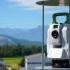
The acquisition of high-quality 3D scan data is the foundation of laser scanning. Utilising robust laser scanning software, such as Leica Cyclone FIELD 360, empowers users to capture accurate data, facilitating the immediate creation of deliverables. One specific functionality that plays a pivotal role in this process is in-field registration. What is in-field registration? Point… Continue reading Optimise your in-field registration workflow with Leica Cyclone FIELD 360
Author: Anya van Oudtshoon
Grow your business with the Leica Captivate TPS monitoring app
It’s easier than you think to grow your Surveying business by offering Monitoring services. Most Surveying businesses at some time will have monitored structures, or a landslide with annual or monthly visits and produced reports in Excel. It’s when those projects become a little more regular that a more efficient solution is beneficial. Leica Captivate… Continue reading Grow your business with the Leica Captivate TPS monitoring app
Laser scanner comparison: Leica RTC360 vs Leica BLK360
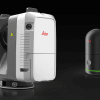
As construction projects become larger and more complex, it is crucial to have the right tools to ensure efficient and accurate work. Two laser scanners, the Leica RTC360 and the next-generation Leica BLK360, are popular choices among building construction professionals. At first glance, the obvious differences between the two scanners are price and size. The BLK360 is… Continue reading Laser scanner comparison: Leica RTC360 vs Leica BLK360
Leica Captivate v8.0 – Overview of new features
Leica Captivate survey field software remains at the forefront of Leica’s ongoing development efforts. As technology and industry demands evolve, Leica’s R&D team remains determined in their efforts of ensuring that the Captivate software not only aligns with but surpasses the requirements and expectations of surveying professionals worldwide. The new Leica Captivate v8.0 was released… Continue reading Leica Captivate v8.0 – Overview of new features
University of Canterbury: Embracing technology for the next generation of Engineers

The University of Canterbury Department of Civil and Natural Resources Engineering is known internationally for its successful engineering programmes. In close consultation with industry, the survey teaching module has been redeveloped in 2023 to prepare the new generation of engineering graduates to suit the needs of the modern profession and clients. Delivered within the second… Continue reading University of Canterbury: Embracing technology for the next generation of Engineers
Harnessing the Power of GNSS for Monitoring Hydro Energy Infrastructure
Hydro energy infrastructure plays a crucial role in the sustainable development of renewable energy sources. The structures that support Hydro Energy are subject to continuous environmental forces, especially in the New Zealand tectonic environment , that can cause deformation, displacement, and even failure. To ensure the long-term integrity and reliability of these assets, it is… Continue reading Harnessing the Power of GNSS for Monitoring Hydro Energy Infrastructure
Introducing the CHC AlphaAir 450 LiDAR: Smaller, lighter sensor for Drone Surveying
3D terrain mapping with drones has become common practice over the last decade. Relatively low-cost drones combined with autonomous mission planning apps and user-friendly photogrammetry software (such as ContextCapture and Leica Infinity amongst others) have provided highly efficient workflows for building accurate and complete 3D models of terrain more quickly and safely than traditional ‘boots… Continue reading Introducing the CHC AlphaAir 450 LiDAR: Smaller, lighter sensor for Drone Surveying
Abley: Optimising augmented reality in construction with vGIS

The recent industry survey by Deloitte for Autodesk “The state of digital adoption in construction report 2023” showed that businesses using digital technologies are more likely to be successful across a number of measures including revenue growth and optimism about the future. The adoption of digital technologies under an organisation-wide strategy that includes training and… Continue reading Abley: Optimising augmented reality in construction with vGIS
Otago University School of Surveying now equipped with Leica TS10 total stations
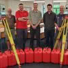
Students at Otago University School of Surveying are now benefitting further from Leica instruments and workflows, following the acquisition of 10 brand new Leica TS10 Total Stations. Richard Harrison from our Christchurch office personally delivered the new equipment and spent time setting up the instruments for the needs of the University, he’ll also be providing… Continue reading Otago University School of Surveying now equipped with Leica TS10 total stations
Custom Rapid Deployment Monitoring Solutions
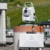
The Global Survey Geomatics team have recently been involved with setting up solutions for monitoring projects. Monitoring projects are often long-term by nature and planned over a period of weeks or months, and usually involve a significant investment in time, equipment, software and expertise. Often they remain in place over many years and as a… Continue reading Custom Rapid Deployment Monitoring Solutions