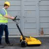
With the Leica DS2000 GPR you’re now able to quickly and safely locate a full range of utilities for a complete picture of what’s going on underground. Ground Penetrating Radar works by using radar technology to create an underground profile of buried items including cables, metallic and non-metallic pipes [concrete, plastic and clay pipes] and… Continue reading Leica DS2000 GPR – Discover what’s going on underground
Author: Angie Fan
Introducing The World’s First Upgradable Lasers
Leica Geosystems has developed the world’s first and only upgradable lasers. The new Leica Rugby Lasers are revolutionising the industry by offering unprecedented flexibility and the ability to adjust to your project’s needs. Designed to adapt. With the Leica Rugby CLA and CLH you can upgrade your lasers to match your application needs. You pay for… Continue reading Introducing The World’s First Upgradable Lasers
Leica Lino Range On Sale Now!

LEICA LINO L2G Green laser beam, up to 4x brighter Horizontal, vertical and cross lines 7h operating time Was $869 NOW $738 LEICA LINO L360 360° horizontal line close to floor level Self levelling, fast and easy set up 180° vertical line Was $769 NOW $653 LEICA LINO L2P5 Self levelling, fast and easy set… Continue reading Leica Lino Range On Sale Now!
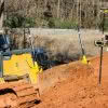
Safer, Faster Utility Detection with Leica GPR
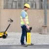
Within the construction industry, there is growing demand for intelligent, easy to use, reliable products that deliver dependable outcomes faster than before. The main issue when detecting underground utilities is being able to obtain reliable, accurate results in order to ensure site safety once earthworks begin. Inaccurate or out of date underground utility data can… Continue reading Safer, Faster Utility Detection with Leica GPR
The CSI Effect – Leica HDS Webinar

** This webinar has already happened but the recording is now available. ** Webinar Recording Available Here The CSI Effect, the second Leica HDS webinar in the series will discuss and demonstrate the key aspects of High Definition Scanning solutions from the approach of the traditional crime scene investigation response. When it comes to public safety, getting… Continue reading The CSI Effect – Leica HDS Webinar
SenSpot™ Wireless Structural Monitoring
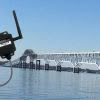
SenSpot™ from Resensys is a cost-effective, easy-to-install, wireless device for long-term bridge and structural monitoring. SenSpot™ sensors provide a versatile platform for remote monitoring of structures on a wide range of structural quantities; examples include strain (stress), vibration, tilt, inclination, temperature, humidity, and acoustic emission events. SenSpot™ are the world’s most energy efficient wireless monitoring… Continue reading SenSpot™ Wireless Structural Monitoring
Countdown To NZIS Conference 2018!

We’re counting down the days to the NZIS Conference 2018 on 17th – 19th May at the Rutherford Hotel in Nelson. This year’s conference promises to be bigger and better than ever with 3 days of powerful interactions planned. The event aims to showcase projects and connect members with the skills they need. The event… Continue reading Countdown To NZIS Conference 2018!
SmartFix Network Growth | Full Site List
New Sites Announced! We’re pleased to announce two more new sites have been added to our SmartFix Network. The two new stations are now active in Dargaville and Oamaru bringing our total stations across NZ to 83. The Hamilton site was also upgraded, going from GPS/Glonass to full GNSS (GPS/Glonass/Galilieo/Beidou). We’re well on the way to… Continue reading SmartFix Network Growth | Full Site List
How Much Faster Is The Leica GS18 T?
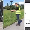
Setting out with a GNSS antenna requires total concentration. Looking at the instructions and values on the controller screen, moving the pole to the required position, and ensuring the pole is vertical by centering the pole bubble – all at the same time – needs careful execution and is not easy, especially when time pressure… Continue reading How Much Faster Is The Leica GS18 T?
Introducing The NEW Leica MCP80 Control Panel
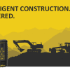
The next generation of machine control. The civil construction industry is embracing intelligent construction to deliver increased productivity and improved safety. Digitisation enables projects to be completed on time, on budget and to the highest specifications. Intelligent construction enables contractors to make business decisions based on real-time data analysis and productivity reporting. Leica Geosystem’s world-class… Continue reading Introducing The NEW Leica MCP80 Control Panel