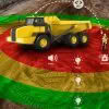
In today’s construction environment, minimizing hazards and increasing safety is extremely important. Creating a safer environment around vehicle and heavy machinery on construction sites is paramount. Construction sites are busy, noisy places with lots going on which makes it difficult to ensure the safety of all personnel on site. Due to their size, all heavy… Continue reading Introducing Leica PA10 Personal Alerts
Author: Angie Fan
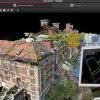
Leica RTC360 Laser Scanner & Collision Investigations
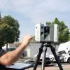
When your crime scene is situated in the middle of a busy intersection in one of LA’s most densely populated cities, you need a fast laser scanning solution. “It can get pretty dicey out there,” says Investigator Weston Hadley, of the Santa Ana Police Department’s Collision Investigations Unit. Until recently, Hadley and his fellow investigators… Continue reading Leica RTC360 Laser Scanner & Collision Investigations
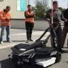
Faster Outdoor Reality Capture with Scan & Go
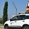
The Scan & Go system is a vehicle-mounted, elevated platform for outdoor laser scanning projects. It is self-leveling, compatible with all makes and models of laser scanners and easily mounted on top of any vehicle. With a growing demand for large volumes of 3D data acquisition, the Scan & Go system delivers extraordinary performance for… Continue reading Faster Outdoor Reality Capture with Scan & Go
Introducing Leica iCON iCT30 – Your New Construction Layout Tool
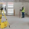
NEW Leica iCON iCT30 The new Leica iCON iCT30 is an entry-level construction layout tool built for one-person layout tasks, it’s designed to increases productivity by minimising labour time and errors, while increasing accuracy and speed. With a measurement range of up to 80m and an angular accuracy of 9 seconds of arc, the Leica… Continue reading Introducing Leica iCON iCT30 – Your New Construction Layout Tool
Survey & Spatial NZ Annual Conference 2019

Are you attending this year’s Survey & Spatial NZ Annual Conference? Later this week we’ll be celebrating 130 years of the association in NZ and we’re proud to have been involved for several of those decades, more recently as a Diamond Partner, actively supporting NZ Surveyors and the industry. The Conference is a must attend… Continue reading Survey & Spatial NZ Annual Conference 2019
Leica HDS Webinar #2: What to consider for your QA/QC workflows in Cyclone REGISTER 360
Join us for the second in our series of HDS webinars designed specifically for Leica users across Australia & New Zealand: Webinar #2: What to consider for your QA/QC workflows in Cyclone REGISTER 360 This webinar discusses the fundamental QA/QC processes in Cyclone REGISTER 360 and demonstrates methods of combining pre-registered and unregistered project data.… Continue reading Leica HDS Webinar #2: What to consider for your QA/QC workflows in Cyclone REGISTER 360
Stream C – Next Level Ground Penetrating Radar
Stream C is a compact array solution for real-time 3D mapping of underground utilities and features. Thanks to increased levels of accuracy provided by a massive antenna array, Stream C Ground Penetrating Radar is able to automatically detect pipes and cables. Stream C Ground Penetrating Radar (GPR) detects underground utilities in real time and quickly produces subsurface GIS-based digital… Continue reading Stream C – Next Level Ground Penetrating Radar
Leica BLK3D: In-Picture Measurements with Optimum Accuracy
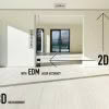
The new Leica BLK3D creates images that contain precise three-dimensional measurements. Understanding how measurements are calculated will ensure you’re getting the best results from your Leica BLK3D. In this article we aim to explain how to create in-picture 3D measurements with optimum accuracy and go through some of the considerations to keep in mind. Accuracy Best… Continue reading Leica BLK3D: In-Picture Measurements with Optimum Accuracy
Public Safety: How to Clear Scenes Faster with Laser Scanning [Webinar]
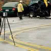
3D laser scanning is a proven way to document crime and crash scenes. With a push of a button, you can “freeze” the scene in time with millions of high-accuracy points and panoramic photography. The resulting data is a true color, extremely detailed, rich, vivid and immersive 3D environment that provides a true and accurate… Continue reading Public Safety: How to Clear Scenes Faster with Laser Scanning [Webinar]
3 Ways Leica BLK360 Improved Workflow
Leica BLK360 International Series #2: 3 ways Leica BLK360 improved workflow Stephen Gross, an Architectural Engineer at Valley Home Improvement in Northampton, Massachusetts, has had his Leica BLK360 since August of 2017. He recently shared with us how using the BLK360 has improved his workflow. #1: Site Visit Changes Before the Leica BLK360, you would… Continue reading 3 Ways Leica BLK360 Improved Workflow