
Introducing the new Leica LOC8 essential security feature for Leica Total Stations. Leica LOC8 is a positioning, tracking and locking solution for Leica total stations that enables the user to remotely track and lock instruments on demand. With this feature users can remotely lock and unlock their total stations, receive notifications of the total station… Continue reading Protect Your Total Station with Leica LOC8
Author: Angie Fan
Finding Survey Marks Faster with Leica Captivate & WMS
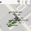
Ask any Surveyor “How long does it take you to find old survey marks?” and the answer is always “Too long!”. Our Survey Team have been testing a new faster way of finding survey marks in the latest version of Leica Captivate. With the release of Leica Captivate version 4.5 it is now possible to… Continue reading Finding Survey Marks Faster with Leica Captivate & WMS
Laser Scanning Just Got Even Easier – Leica Cyclone Field360 App

The latest version of the Leica Cyclone FIELD 360 mobile app streamlines field data and documentation with post-processing activity, making your reality capture experience powerfully efficient, accurate and flexible. It is fully compatible with the Leica RTC360 / Leica RTC360 LT and the Leica BLK360 laser scanners and is now available on iOS and Android… Continue reading Laser Scanning Just Got Even Easier – Leica Cyclone Field360 App
SmartFix RTK Reference Station Network – Full Site List
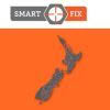
SmartFix is NZ’s most extensive reference station network that is continually growing, we’re well on the way to achieving our mission of 100% NZ coverage. SmartFix RTK Reference Station Network delivers: cm level real-time kinematic corrections in NZGD2000 post-processing solutions sub-meter GIS corrections Providing a real-time kinematic (RTK) correction service over the internet, and RINEX… Continue reading SmartFix RTK Reference Station Network – Full Site List
WEBINAR: What’s New in Leica Cyclone 3DR
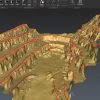
What’s new in Leica Cyclone 3DR, the all-in-one deliverable solution Leica Cyclone 3DR is a seamless extension of the Cyclone product family which works hand in hand to take users from field data collection with Cyclone FIELD 360 through registration in Cyclone REGISTER 360 and deliverable creation in Cyclone 3DR. Leica Cyclone 3DR has taken the popular features of 3DReshaper and… Continue reading WEBINAR: What’s New in Leica Cyclone 3DR
Be Our Guest at CONEXPO 2020!

Don’t miss this offer to go to CONEXPO for FREE! North America’s largest construction trade show, CONEXPO is held in Las Vegas – March 10-14, 2020 and attracts the world’s leading construction brands with over 2800 exhibitors. Purchase two full Leica iCON 3D Machine Control Systems and we’ll send you there for the trip of… Continue reading Be Our Guest at CONEXPO 2020!
Leica & Autodesk | Bridging the Information Gap

Global industry partners Leica Geosystems and Autodesk have been working closely together to help close the information loop between design office and site. Leica offers a range of comprehensive set out solutions for both the survey and construction industries. Leica iCON Build and iCON Site are primarily targeted towards the vertical/horizontal construction markets, whereas, Leica… Continue reading Leica & Autodesk | Bridging the Information Gap
Introducing the Amazing NEW Leica BLK2GO
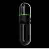
We’re excited to welcome the newest member of the BLK family – Meet the amazing new Leica BLK2GO handheld laser scanner. This new mobile laser scanner was recently revealed at HxGN LIVE in Las Vegas. The Leica BLK2GO is designed to scan complex spaces with unprecedented efficiency and speed thanks to a combination of LiDAR,… Continue reading Introducing the Amazing NEW Leica BLK2GO
Choosing the Closest SmartFix Mountpoint
For survey customers it is vital to select a SmartFix Mountpoint that is closest to your working area. By selecting the closest Mountpoint you improve the likelihood of obtaining a good GNSS fix, reduce the need for doing a site localization and most importantly minimise the distance dependent error in the GNSS observation. If the… Continue reading Choosing the Closest SmartFix Mountpoint
Expert Insights: What’s new with Leica FlexLine Total Stations?
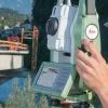
Flexline with AutoHeight are the newest generation of total stations from Leica Geosystems, they replace the former FlexLine instruments that were launched more than a decade ago. In this interview, Hans Martin Zogg, Business Director for total stations, explains what’s new with the latest Leica FlexLine total stations. What’s New With Leica’s Latest Total Stations?… Continue reading Expert Insights: What’s new with Leica FlexLine Total Stations?